

About UAV Forecast – A Simple Yet Amazing App for Drone Pilots
August 16, 2019UAV Forecast
Free, $3.99 per month or $23.00 per year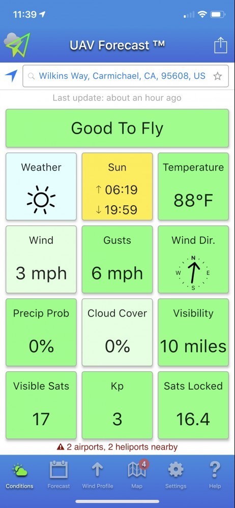
Pros
- Quick-Look Status
- Customizable
- Accurate
Cons
- None
How many apps do you need as a drone pilot? For the purist, you’ll probably hear them say “One”. For the tinkerer, geek and so on, that answer would probably be something like “As many as you can fit on your device”. Either way, when it comes to selecting apps for your drone, there’s no shortage of options.
The hard part is trying to weed out the crap and find the few true gems that are the must-haves for your drone app collection. To that end, I want to tell you About UAV Forecast and let you know why it’s listed as one of my Top App Picks.
We’ll discuss if you really need another weather app, learn about UAV Forecast, find out what makes it so special and talk about some other apps that might be a better fit for your needs.
Table of Contents
In the end, I hope this post helps you find the right app that provides the features you want and gives you the information you need. Let’s get started…
THIS POST MAY CONTAIN AFFILIATE LINKS. PLEASE SEE MY AFFILIATE DISCLOSURE FOR MORE INFORMATION.
 Do I Really Need Another Weather App?
Ultimately, no. Of course, you’re getting that advice from someone who has 9 weather apps on his phone, not including UAV Forecast, so really 10. Now, that’s just me being a bit lazy…
I used to check the weather on 3 different websites, back in the day and when their corresponding apps were released I just downloaded them. Then I had the 1 that came with my phone’s OS and I added a few more because I liked their features or the way they present certain data (I used to live in South Florida so hurricane information was important to me).
I really just need to take the time to go through each, once again, and narrow it down to two or three max.
In the end, it’s up to you to determine how many weather apps you need. I recommend you consider features, display/presentation (what you get at a glance) and accuracy (there’s no point in using a weather app that’s always wrong). That’s one of the reasons I used AccuWeather for so long. They just seemed to get it right.
 Tell Me About UAV Forecast?
UAV Forecast is another weather app but it’s tailored to the drone pilot. It provides the necessary information that a drone pilot would find useful and it displays that information in an easy to understand format that’s really more of a snapshot that you can glance at and know what’s what.
It’s not only an app but a website as well and offers both a free and subscription option. The free option allows you to use all the features the app and site have to offer but limits you to a 24-hour forecast. The pay-for option expands the forecast range to 7 days.
For most of us, we’re more of the “I’ll check it just before I need it” mentality and the 24-hour limitation on the free option isn’t an issue. For others, mainly those of us who are part 107 certified and planning a job a few days out, the subscription service makes more sense. Still, I recommend checking again just before the flight to be sure the weather hasn’t changed significantly since the last time you checked it.
Now let’s talk about the actual features and information provided by UAV Forecast…
 What Makes UAV Forecast So Special?
There’s a lot that makes UAV Forecast special. Here’s a list of some of my favorite features:
Thresholds
One of the best things about UAV Forecast is the ability to set your own thresholds for various categories. Set the maximum wind speed, minimum and maximum temperatures, cloud coverage, visibility, minimum visible GPS satellites, and more! You can even choose whether to include GLONASS, Galileo individually!
UAV Forecast does a pretty good job of picking the default settings but it’s nice to be able to customize them to your specific preferences.
Units
How many times have you used an app and it’s locked to a specific speed or temperature reference? You don’t have that problem with UAV Forecast. Set your wind reference unit to mph, km/h, knots, m/s and more. The same goes for altitude, temperature, and visibility. Mix and match to your heart’s delight.
Display/Presentation
When you open the app, you’re presented with your current weather information in a 3 x 4 square grid with a bar at the top telling you if it’s good to fly or not. This screen is called Conditions. What’s nice about this is square is also color-coded. If everything is in the green, you’re good. If something is marginal, it might be displayed in yellow to draw your attention to it. Guess what the next color is… Yep, red. Anything in red is a warning that it’s not good.
The squares are divided up as follows:
Weather
This shows a little icon of the basic weather you can expect. A sun means it’s sunny, clouds mean it overcast, etc.
Sun
This square simply shows you the sunrise and sunset times for the selected location. This can be great information to know when operating under part 107 as sunrise and sunset play important roles in the rules.
Temperature
As you’d expect, this one shows you the current temperature in the format you’ve selected (Fahrenheit, Celsius, etc.).
Wind
This one shows the current wind speed. Good to know if you are uncomfortable flying in higher wind speeds. It will also help you calculate how far you can go and still be able to return safely within your drone’s and battery’s flight range.
Gusts
Wind speed is one thing but gusts should also be considered. If you’re flying near your drone’s wind speed limit and gusts come up exceeding them, you can be in a world of hurt.
Wind Direction
A little arrow shows you the wind direction relative to north. I wish this offered a direction based on your flight path but UAV Forecast has no way of determining that so north it is.
Precipitation Probability
This just shows you what the chances of any precipitation are. This isn’t just a rain prediction. It’s really for all forms of precipitation such as rain, snow, hail, sleet and so on.
Cloud Cover
I’m pretty sure you can guess what this one is for. It will let you know how much of the sky is covered by clouds.
Visibility
You might be concerned with how far you can see, especially for jobs that require you to fly long distances. The visibility square has you covered.
Visible Satellites
Ever wonder how many GPS satellites can be seen from your location? Wonder no more. This shows you the raw number of satellites that you should be able to see barring any obstacles like mountains, buildings, etc.
Kp
I really like this one. It’s an index that measures geomagnetic disruption caused by solar activity. The more activity, the higher the chances that it will interfere with your GPS lock and even your controllable range.
Satellites Locked
This one is much like the Visible Satellites box but takes into account elevation mask, time of day (believe it or not GPS actually is worse at night), location (interference increases as you get closer to the equator) and the current Kp index information. When it crunches all of that information together, it produces a pretty accurate count of how many GPS satellites you should be able to lock onto with your drone.
Forecast
The forecast is pretty accurate. I have yet to see a major deviation from what was predicted. What’s nice is you get that “what’s going on now” snapshot look but you can also click on Forecast and get an hour-by-hour forecast, color-coded just like the blocks.
 Wind Profile
This is another great feature. You can get wind speed, gust speed and temperature information for multiple altitudes. These include 33ft, 100ft, 250ft, 500ft, 1000ft all the way up to 5000ft! This can come in handy if you’re planning to fly and various altitudes.
Situational Awareness
Like many other drone-related apps, UAV Forecast has a map view and overlays colored circles representing different warnings and notifications. These include; TFRs/NOTAMs, DJI no-fly zones, large airports, medium airports, small airports, seaplane bases, heliports, and a range guide. You can even adjust the no-fly zone options such as radius or even turn off specific categories!
As you can see UAV Forecast has a lot to offer and presents it in such a way as to make it easy to decipher not only each individual square and associated factor but to get a quick overall picture as well.
What Are Some Other Apps I Might Consider Instead?
Now, UAV Forecast isn’t the only app out there. That said, it’s designed for one thing and one thing only and it does it very well. Still, here are some other apps you may want to consider instead or in addition to…
KittyHawk
This is not a weather app. It’s a full-on drone solution app. Flight information, LAANC authorizations, logging and so on are all part of this solution. It does, however, offer some basic weather information such as temperature, wind, gusts, visibility, humidity, cloud cover, daylight/sunset, Kp index, and expected GPS signal. That said, it’s a right-now snapshot and doesn’t offer any type of forecasting.

General Weather Apps
If you don’t need satellite information or maybe even the Kp index info, then any of your other weather apps should provide most of the information you need. Ones I particularly like are AccuWeather, The Weather Channel, and WeatherBug.
So really, as far as done-specific apps go, there’s only 1 that I would consider instead of UAV Forecast and that one only offers a right-now look. I’m sure there are others out there. I just don’t know who they are or what they have to offer.
Conclusion
So, now that I’ve told you About UAV Forecast, what do you think? I for one love it. It’s my go-to app whenever I even think about flying. I just love the quick-look feature that the Conditions screen presents and I know right away if I’m good to fly or not.
Now I’d like to hear from you… Do you use UAV Forecast? If so, do you like it? Is there a feature I didn’t list here? Do you know of an alternative that you think should be listed here? Please let me know by commenting below.
Thank you,
Scott Hinkle
MavicManiacs.com


Weather apps are definitely a big deal when you are flying drones. You don’t want to go out for a drone flight and then suddenly have it get stuck in dangerous weather. So I think it sounds like a good idea to have a mix of useful apps.
Pay subscription sounds like a good idea because sometimes you want to know a week in advance if possible. I like all the different aspects of the weather they tell you about especially the Geomagnetic feature.
Kitty Hawk sounds interesting and would that be the one to get for someone who wanted to have only one app for their drone? Thanks for this useful information.
Hello,
I agree that the pay-for option is good for those that want to know more than 24 hours in advance.
As for KittyHawk, if you were to get just one app, that’s probably the one to get. Not only does it give you the right-now weather info but it can actually control DJI drones too! Still, I’m one of those guys that likes 1 app for 1 purpose as I feel that most of the time they do a much better job at that one task than an all-in-one solution.
Thanks for commenting,
Scott
I’m only just starting out with my drone and I’ve already started using this app and I’m finding it really useful. I love the design and the level of detail it offers is great.
The ability to customise it with your own thresholds is what I think makes it a cut above the rest. So much easier than having to manually check and remember every single time. What other features would you like to see in the future?
Thanks a lot.
Hello there,
That’s the best thing about this app…it’s so simple and the interface just works!
I’ll be honest with you, I haven’t really set any thresholds. I like the default so far.
That’s a really good question… I like apps that focus on their main objective over ones that try to do everything. Frankly, the map feature is overkill and I use AirMap for my map and LAANC needs. That said, there are others that like an all-in-one approach. If I were to add a feature it would be LAANC authorization and maybe DJI drone control.
Thanks for taking the time to comment,
Scott
Hello Scott,
I recently got the Mavic Pro for my cousin who is into photography and I got scared a bit concerning the safety and potential of the drone crashing so I decided to have a quick look at other things that might help to reduce the potential of the drone being damaged rather quickly. I must say, this UAV Forecast app would be just perfect to add to his arsenal.
I like the various customization options it provides and the accuracy of the forecasts. I will surely suggest this app to him and I really hope it will work well for him. Besides, there no need to subscribe to it, the free option is probably enough for him.
Hi there!
The Mavic Pro is a great drone. I’ve had mine for over 2 years and I love it to this day! The potential for accidents is always there. Proper flight preparation and awareness go a long way toward mitigating potential issues.
UAV Forecast is one app that will help with awareness and planning. Wind speed alone is good to know. You’re right about the subscription. I use the free version myself.
You might be interested in a couple of my other articles:
About Drone Accidents – Excellent Tips On What To Do If Your Drone Hits a Car
About Drone Insurance – Essential Protection for 2019
Drone Safety Tips – 15 Simple Ways to Make Your Next Flight a Safe One
Mavic Pro Preflight Checklist – Steps to Take For Each Flight – Updated!
Check them out and let me know wha you think…
Thank you,
Scott
Hello Scott,
This app looks like the best forecast app I’ve seen. Not like I’ve used many but being able to tell the wind and sun and even the cloud situation looks like a very awesome feature to me.
You said it’s used mostly by those who use drones but I feel people who travel and those who are weary of the weather should definitely try this forecasting app. I like that it has a free option and the ability to set thresholds too.
I’m definitely downloading this app. Thanks!
Hello,
I really do like this app for the weather information, especially when it relates to my drone flying. It’s true that anyone can use it, drone pilot or not. I just think it’s tailored to the drone pilot and it doesn’t offer the moving map overlay weather info you can get in other weather apps.
Let me know what you think of it after you’ve used it for a while.
Thanks,
Scott
Hi Scott,
This is a great review of the UAV Forecast app. It is quite detailed and seems to have the necessary features for planning a drone flight. I like the Kp index feature which offers you really important info about the geomagnetic interference.
I have a few queries. I am not sure if I have missed them during my review of the content.
1. Can it tell you about a no flying zone?
2. How do you know or calculate the battery usage?
3. I am not certain but can you take the picture of sunrise and sunset or maybe an interesting cosmic even like lunar eclipse?
4. Can you see important news happening on the ground when you are up flying?
Thank you for sharing a piece of useful information for Drone lovers.
Hi there,
I agree the Kp index info is nice to know. As for your questions…
1) Yes, the no-fly information will be on the map view.
2) Battery usage is more something you notice in your drone controlling app and you can estimate your flight time after you’ve flown a bit. What UAV Forecast helps you to determine is wind speed and direction which will affect your flight time if you’re flying with or against the wind, etc.
3) The UAV Forecast app doesn’t have the ability to take pictures but it does give you sunrise and sunset information so you know when to be up to take them. You can use your phone, tablet or drone to take the actual picture, etc.
4) No, UAV Forecast doesn’t alert you t real-time information. AirMap will alert you to traffic it knows about and it’s one app that I also recommend to pilots.
Thank you for taking the time to reach out,
Scott